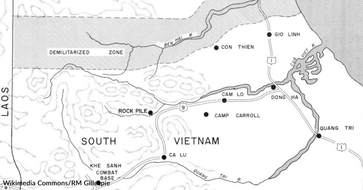
Route 9, Dong Ha to Lao Bao Vietnam
This piece includes two videos of Route 9 in Vietnam. This first video is a compilation of amateur videos probably taken by a grunt Marine, possibly from the 3rd Bn., 9th Marines during his tour in Vietnam.
Route 9 is familiar to Marines who served in the I Corps during Vietnam, as it was a main route east to west across the northern part of then South Vietnam, not far below the DMZ. Just seeing some of these pictures will bring back memories. I know they did for me.
Route 9 went from Dong Ha, a town near the delta of the Qua Viet River on the coast of Vietnam, all the way to the Laotian border town of Lao Bao. It takes you through places with very familiar names for most Marines, like Cam Lo, the Rock Pile, and Khe Sanh. It was as often as not, especially during the Tet Offesive of 1968, contested territory and each of the places mentioned previously saw a great deal of serious enemy action, much of it entering into Marine Corps history.
In January of 1969, Cam Lo was an artillery base occupied by the 2nd Bn. 12th Marines, with security provided by the 2nd Bn., 9th Marines. On the second of February, the Viet Cong 27th Independent Battalion attacked the Cam Lo District political headquarters with full force. The Viet Cong would lose 111 killed, and the Marines suffered 3 KIA. But it was only one of the places that came under attack by the combined efforts of the Viet Cong and the North Vietnamese Army (NVA) all across the length and width of South Vietnam during the Tet Offensive.

There was a Marine combat base at the Rockpile and an observation post on top of it, from which Marines would observe enemy movement and radio information to the Marine Base at Dong Ha. This solitary rock outcropping sat along Route 9, which was a major supply route as well as communications and commercial route in that area of Vietnam. On a couple of occasions, units from 3rd Recon would be called upon to go on supply convoys down this highway as security, but most of the time they operated reconnaissance patrols on either side of the highway, searching for enemy movement, supply lines, ammunition caches, and the like.
Route 9 also went through the village of Khe Sanh on its way to the Laotian border. Outside of the village was the forward Marine Corps airfield, also called Khe Sanh. It was there, on January 21, 1968, that the NVA launched its first, longest, and bloodiest attack on the Marines at Khe Sanh. For the next 77 days, the Marines would be isolated and cut off from supply lines, except for those delivered by air. Route 9 was essentially closed by the enemy and would not be opened again until toward the end of the siege. At that time, it was units from the 1st Cavalry Division (Airmobile), or 1st Air Cav, that came down Route 9 to help relieve the siege. As the lead units encountered stiff resistance from the NVA on the road, units from the rear were picked up by helicopter and leap-frogged behind the NVA to join the attack there.

In the end, when the Tet Offensive finally petered out, the Marines, who had fought with skill, determination, and great courage, had suffered great losses, but they had not only defeated the NVA efforts to take the South, they had levied a very heavy price on the enemy. By the end of the offensive, the NVA had lost up to 50,000 KIA, 24,000 weapons were captured, and the Viet Cong had suffered such catastrophic losses that they ceased to exist as an effective fighting force of any size.
In this second video, you will see that Route 9 remains the main highway across the middle of the country. It is the commercial and transportation mainline in that area and runs through some profoundly beautiful and dramatically varying landscape. See what Route 9 looked like then, during the Vietnam War, and what it looks like now. As is true everywhere, things change a great deal over 50 years’ time.
History has a way of changing the story of places over time. While during the Vietnam War, highway 9 gave over to an often dangerous and bloody set of stories, it is now just another main highway, providing a connection between cities, towns, and neighboring countries in modern Vietnam.